| |
|
 |
See your surroundings more clearly with BlueChart g2 data. With BlueChart g2, you'll get detailed marine cartography that provides convenient viewing of nautical content. BlueChart g2 allows you to see your vessel's precise, on-chart position in...
Read more 
|
|
 |
| |

|
|
Coverage of the Pacific Ocean from the Hawaiian to Mariana Islands. Includes coverage of Guam, Midway, and Johnston Atoll. General coverage of Palmyra Atoll and the Marshall Islands also included.
Read more
|
|
|
| |
|
|
On SD Memory Card BlueChart g2 Vision offers the same rich detailed charting of BlueChart g2 to help you get the most out of your unit. In addition, g2 Vision features a growing database of high-resolution satellite imagery, above and below the water 3D p
Read more
|
|
|
| |
|
|
See your surroundings more clearly with BlueChart g2 data. With BlueChart g2, you\'ll get detailed marine cartography that provides convenient viewing of nautical content. BlueChart g2 allows you to see your vessel\'s precise, on-chart position in...
Read more
|
|
|
| |

|
|
Garmin Bluechart G2 Vision, Vus401s, Bermuda, Micro/sd . Get a Fresh Perspective Get a fresh perspective when you take to the water with BlueChart g2 Vision. With BlueChart g2 Vision data, you ll get detailed marine cartography that provides convenient vi
Read more
|
|
|
| |

|
|
HXAE004R Covers:General coverage of the coasts of the Malay Peninsula, Thailand, Cambodia, Vietnam, and China east to Quanzhou, including Hainan Island and Macau. Included in this overall general coverage are numerous detailed charts covering areas...
Read more
|
|
|
| |
|
|
Enhance your boats marine instrumentation capabilities. This versatile thru-hull sensor provides depth and water temperature data and sends it to your NMEA 0183 Garmin digital marine instrument display or chartplotter.
Read more
|
|
|
| |
|
|
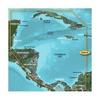
HXUS031R Covers:Detailed coverage of the northern coast of Central America from Cancun, Mexico to Barranquilla, Colombia, including the Panama Canal in its entirety. General coverage of the northern half of the Gulf of Panama. Also includes detailed...
Read more
|
|
|
| |
|
|
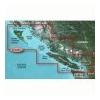
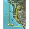
Detailed coverage of the West coast of North America from Vancouver, Can. to the U.S. border with Mexico. Detailed coverage includes Puget Sound, San Francisco Bay, San Diego Harbor, the Columbia and Snake Rivers, and the California Delta to Sacramento an
Read more
|
|
|
| |
|
|
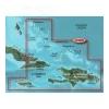
HXUS029R Covers:FEATURING DATA FROM EXPLORER CHARTS FOR THE BAHAMAS!!! Detailed coverage from Eleuthera Island, Bahamas to the Dominican Republic
Read more
|
|
|
| |
|
|
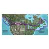
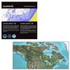
Canada LakeVü™ HD - microSD™/SD™ f/GPSMAP® Series, Montana® & Oregon® HandheldsWith maps of more than 6, 000 Canadian lakes - many with 1 foot contours throughout - this high definition-mapping product brings new levels o
Read more
|
|
|
| |
|
|
Plug a BlueChart g2 Vision SD data card into your chartplotter, and youll get a whole new perspective on nautical navigation. BlueChart g2 Vision offers the same rich detailed charting of BlueChart g2 to help you get the most out of your unit. In addition
Read more
|
|
|


 Switch to grid view