| |

|
 |
Bail Mount with Knobs, MFG# 010-11967-00, for echoMap 70 and GPSMAP 741. Mount accessory. Made in China.
Read more 
|
|
 |
| |
|
|
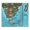
Af. to the mouth of the Zambezi River. Detailed coverage includes Port Elizabeth and Durban, S. Af., Maputo, Moz., as well as the Prince Edward Islands. 010-C0752-00 Garmin Vaf452S Knysna Sa To Beira Mz G2 Vision Sd VAF452S Covers: Coverage of the southea
Read more
|
|
|
| |

|
|
Card Includes: Detailed Mapping Software of Calcasieu Lake, LA, including New Orleans, the Mississippi River Delta, Lake Ponchartrain and Lake Maurepas, over to Vermilion Bay
Read more
|
|
|
| |
|
|
On SD Memory Card BlueChart g2 Vision offers the same rich detailed charting of BlueChart g2 to help you get the most out of your unit. In addition, g2 Vision features a growing database of high-resolution satellite imagery, above and below the water 3D p
Read more
|
|
|
| |
|
|
VAE005R Covers: General coverage of the coasts of the Philippines, portions of Indonesia, including Java, and Malaysia located to the east of Singapore and west of Halmahera Island, and portions of East Timor. Included in this overall general coverage are
Read more
|
|
|
| |

|
|
Garmin B744VL Long Stem Bronze Thru-Hull Depth/Temp/Speed with FB - 8 Pin
Read more
|
|
|
| |
|
|
Card Includes: Detailed Mapping Software of Penobscot Bay Through Gloucester
Read more
|
|
|
| |
|
|
Detailed coverage of the West coast of North America from Vancouver, Can. to the U.S. border with Mexico. Detailed coverage includes Puget Sound, San Francisco Bay, San Diego Harbor, the Columbia and Snake Rivers, and the California Delta to Sacramento an
Read more
|
|
|
| |

|
|
See your surroundings more clearly with BlueChart; g2 data. With BlueChart g2, you'll get detailed marine cartography that provides convenient viewing of nautical content. BlueChart g2 allows you to see your vessel's precise, on-chart position in...
Read more
|
|
|
| |
|
|
Garmin 010-00703-00 Intelliducer Transom Mount, Transducer determines water depth and temperature and sends the data to your NMEA 2000 device
Read more
|
|
|
| |
|
|
Enhance your boats marine instrumentation capabilities. This versatile thru-hull sensor provides depth and water temperature data and sends it to your NMEA 0183 Garmin digital marine instrument display or chartplotter.
Read more
|
|
|
| |
|
|
VAW450S Covers: Detailed coverage the of Kuwait, Saudi Arabia, Qatar, United Arab Emirates, along the southern coast of the Gulf, including Al-Fuhaihil, Ad-Dammam, Bahrain, Ad-Dauha, and Abu Dhabi. Coverage of Iran along the northern coast of the Gulf inc
Read more
|
|
|


 Switch to grid view