| |
|
 |
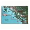
Canada LakeVü™ HD - microSD™/SD™ f/GPSMAP® Series, Montana® & Oregon® HandheldsWith maps of more than 6, 000 Canadian lakes - many with 1 foot contours throughout - this high definition-mapping product brings new levels o
Read more 
|
|
 |
| |
|
|
Card Includes: Detailed Mapping Software of Penobscot Bay Through Gloucester
Read more
|
|
|
| |

|
|
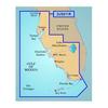
Card Includes: Detailed Mapping Software of Calcasieu Lake, LA, including New Orleans, the Mississippi River Delta, Lake Ponchartrain and Lake Maurepas, over to Vermilion Bay
Read more
|
|
|
| |
|
|
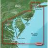
VUS038R Covers: Coverage of Raritan Bay to Virginia Beach including Tarrytown Fire Island Inlet the entire New Jersey coastline the C D Canal Delaware Bay the Delaware River to Trenton Chesapeake Bay Baltimore the Potomac River to Washington D.C. Chincote
Read more
|
|
|
| |
|
|
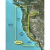
Detailed coverage of the West coast of North America from Vancouver, Can. to the U.S. border with Mexico. Detailed coverage includes Puget Sound, San Francisco Bay, San Diego Harbor, the Columbia and Snake Rivers, and the California Delta to Sacramento an
Read more
|
|
|
| |
|
|
On SD Memory Card BlueChart g2 Vision offers the same rich detailed charting of BlueChart g2 to help you get the most out of your unit. In addition, g2 Vision features a growing database of high-resolution satellite imagery, above and below the water 3D p
Read more
|
|
|
| |
|
|
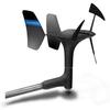
gWind™ Transducer OnlyThe gWind transducer features twin-fin technology with 3-bladed propeller for more accurate TWS in lighter air while the twin-fin design gives a more stable TWA. The 3-bladed propeller, unlike a cups design, is always efficient
Read more
|
|
|
| |
|
|
Garmin 010-00703-00 Intelliducer Transom Mount, Transducer determines water depth and temperature and sends the data to your NMEA 2000 device
Read more
|
|
|
| |
|
|
Enhance your boats marine instrumentation capabilities. This versatile thru-hull sensor provides depth and water temperature data and sends it to your NMEA 0183 Garmin digital marine instrument display or chartplotter.
Read more
|
|
|
| |
|
|
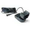
GND™ 10 Black Box BridgeThe Garmin GND 10 black box bridge seamlessly integrates Nexus instruments and sensors with the Garmin family. It converts data between the Nexus network and NMEA 2000 to provide trouble-free compatibility between Nexus and G
Read more
|
|
|
| |

|
|
HXEU015R Covers:including all of the Greek coast and Aegean Sea; Turkey from Istanbul and Sea of Marmara to Antalya; and Brindisi, Italy. Part Numbers Variations: 010-C0773-20, 753759091705
Read more
|
|
|
| |
|
|
Covers: Crystal River through Key Largo
Read more
|
|
|


 Switch to grid view