| |
|
 |
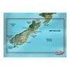
Maps & Add-Ons . VPC417S Covers: Includes the entire coast of the South Island, including the Bounty Islands to the southeast and Snares islands to the southwest; also includes the southernmost part of the North Island, from Foxton Beach to Cape Turnagain
Read more 
|
|
 |
| |

|
|
Garmin BlueChart G2 Vision VSA001R South America East Coast - 010-C1062-00 Get a fresh perspective when you take to the water with BlueChart® g2 Vision®. With BlueChart g2 Vision data, you'll get detailed marine cartography that provides convenient...
Read more
|
|
|
| |

|
|
Navionics 916P-2 Platinum Plus NW ALEUTIAN ISLANDS, WESTERN ALASKA, NORTHERN ALASKA From Shumagin Islands to Demarcation Bay, including Dutch Harbor and the Pribilof Islands. Compatibility Guide
Read more
|
|
|
| |
|
|
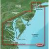
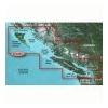
VUS038R Covers: Coverage of Raritan Bay to Virginia Beach including Tarrytown Fire Island Inlet the entire New Jersey coastline the C D Canal Delaware Bay the Delaware River to Trenton Chesapeake Bay Baltimore the Potomac River to Washington D.C. Chincote
Read more
|
|
|
| |
|
|
010-C0780-00 Garmin Veu043R Iceland and Faeroe Islands Bluechart G2 VEU043R Covers: Includes detailed coverage of all of Iceland including the cities of Reykjavik and Akureyri. Also includes detailed coverage of the Faeroe Islands including Stromo, Ostero
Read more
|
|
|
| |
|
|
Garmin VEU054R - Vestfjd-Svalbard-Varanger - SD Card 010-C0790-00 Garmin Veu054R Vestfjd Svalbard Varanger Bluechart G2 VEU054R Covers: Detailed coverage of the northern Norway coast from Vestfjorden to Vadso including Troms and Narvik. Also includes cove
Read more
|
|
|
| |
|
|
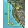
Detailed coverage of the West coast of North America from Vancouver, Can. to the U.S. border with Mexico. Detailed coverage includes Puget Sound, San Francisco Bay, San Diego Harbor, the Columbia and Snake Rivers, and the California Delta to Sacramento an
Read more
|
|
|
| |
|
|
On SD Memory Card BlueChart g2 Vision offers the same rich detailed charting of BlueChart g2 to help you get the most out of your unit. In addition, g2 Vision features a growing database of high-resolution satellite imagery, above and below the water 3D p
Read more
|
|
|
| |
|
|
See your surroundings more clearly with BlueChart g2 data. With BlueChart g2, you\'ll get detailed marine cartography that provides convenient viewing of nautical content. BlueChart g2 allows you to see your vessel\'s precise, on-chart position in...
Read more
|
|
|
| |
|
|
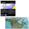
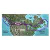
Canada LakeVü™ HD - microSD™/SD™ f/GPSMAP® Series, Montana® & Oregon® HandheldsWith maps of more than 6, 000 Canadian lakes - many with 1 foot contours throughout - this high definition-mapping product brings new levels o
Read more
|
|
|
| |
|
|
See your surroundings more clearly with BlueChart g2 data. With BlueChart g2, you'll get detailed marine cartography that provides convenient viewing of nautical content. BlueChart g2 allows you to see your vessel's precise, on-chart position in...
Read more
|
|
|
| |

|
|
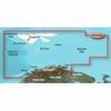
Garmin Bluechart G2 Vision, Vus401s, Bermuda, Micro/sd . Get a Fresh Perspective Get a fresh perspective when you take to the water with BlueChart g2 Vision. With BlueChart g2 Vision data, you ll get detailed marine cartography that provides convenient vi
Read more
|
|
|


 Switch to grid view