| |

|
 |
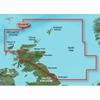
010-C0844-00 Garmin Veu500S Blythe To Lowestoft Bluechart G2 Vision VEU500S Covers: Detailed coverage of the English coast from Blyth to Lowestoft, including Newcastle, Middlesbrough, Kingston Upon Hull, The Wash, and Boston. Also includes coverage of the
Read more 
|
|
 |
| |
|
|
Plug a BlueChart g2 Vision SD data card into your chartplotter, and youll get a whole new perspective on nautical navigation. BlueChart g2 Vision offers the same rich detailed charting of BlueChart g2 to help you get the most out of your unit. In addition
Read more
|
|
|
| |
|
|
BlueChart g2 Vision offers the same rich detailed charting of BlueChart g2 to help you get the most out of your unit. In addition, g2 Vision features a growing database of high-resolution satellite imagery, above and below the water 3D perspective, auto g
Read more
|
|
|
| |
|
|
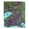
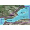
VEU055R Covers:Detailed coverage of inland Finnish lakes including Inarijarvi, Miekojarvi, Simojarvi, and Kiantajarvi. Also includes detailed coverage of Oulujarvi, Pielinen, Saimaa, Paijanne, Nasijarvi, Lohjanjrvi, and others.
Read more
|
|
|
| |

|
|
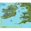
VEU482S Covers:Detailed coverage of Southern Ireland from Wexford to Ventry. Also includes detailed coverage of Dungarvan, Cork, and Cahersiveen.3-D View = Yes | Aerial Photos = Yes | Port Plans = Yes | Card Format = SD
Read more
|
|
|
| |

|
|
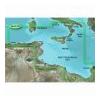
VEU465S Covers:Detailed coverage from Bermeo, Spain to St. Nazaire, France including La Rochelle, Cap Ferret, and La Gironde.3-D View = Yes | Aerial Photos = Yes | Port Plans = Yes | Card Format = SD
Read more
|
|
|
| |
|
|
On SD Memory Card BlueChart g2 Vision offers the same rich detailed charting of BlueChart g2 to help you get the most out of your unit. In addition, g2 Vision features a growing database of high-resolution satellite imagery, above and below the water 3D p
Read more
|
|
|
| |
|
|
Garmin VEU003R - Great Britain, Northeast Coast - SD Card
Read more
|
|
|
| |
|
|
BlueChart g2 Vision offers the same rich detailed charting of BlueChart g2 to help you get the most out of your unit. In addition, g2 Vision features a growing database of high-resolution satellite imagery, above and below the water 3D perspective, auto g
Read more
|
|
|
| |
|
|
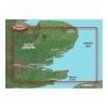
VEU461S Covers: Great Yarmouth to Folkestone - including Thames Estuary and River to Teddington Lock.
Read more
|
|
|
| |
|
|
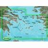
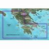
010-C0834-00 Garmin Veu490S Greece West Coast and Athens Bluechart G2 VEU490S Covers: Detailed coverage of the southwestern coast of Greece from Vlore, Albania to Athens, Greece. Also includes detailed coverage of Preveza, Patra, Peloponnisos, and the Cyc
Read more
|
|
|
| |
|
|
VAW450S Covers: Detailed coverage the of Kuwait, Saudi Arabia, Qatar, United Arab Emirates, along the southern coast of the Gulf, including Al-Fuhaihil, Ad-Dammam, Bahrain, Ad-Dauha, and Abu Dhabi. Coverage of Iran along the northern coast of the Gulf inc
Read more
|
|
|


 Switch to grid view