| |
|
 |
BlueChart g2 Vision offers the same rich detailed charting of BlueChart g2 to help you get the most out of your unit. In addition, g2 Vision features a growing database of high-resolution satellite imagery, above and below the water 3D perspective, auto g
Read more 
|
|
 |
| |
|
|
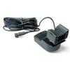
Garmin 010-00703-00 Intelliducer Transom Mount, Transducer determines water depth and temperature and sends the data to your NMEA 2000 device
Read more
|
|
|
| |
|
|
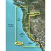
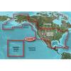
Detailed coverage of the West coast of North America from Vancouver, Can. to the U.S. border with Mexico. Detailed coverage includes Puget Sound, San Francisco Bay, San Diego Harbor, the Columbia and Snake Rivers, and the California Delta to Sacramento an
Read more
|
|
|
| |
|
|
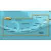
HXUS029R Covers:FEATURING DATA FROM EXPLORER CHARTS FOR THE BAHAMAS!!! Detailed coverage from Eleuthera Island, Bahamas to the Dominican Republic
Read more
|
|
|
| |
|
|
On SD Memory Card BlueChart g2 Vision offers the same rich detailed charting of BlueChart g2 to help you get the most out of your unit. In addition, g2 Vision features a growing database of high-resolution satellite imagery, above and below the water 3D p
Read more
|
|
|
| |

|
|
Coverage of the Pacific Ocean from the Hawaiian to Mariana Islands. Includes coverage of Guam, Midway, and Johnston Atoll. General coverage of Palmyra Atoll and the Marshall Islands also included.
Read more
|
|
|
| |
|
|
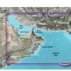
VAW450S Covers: Detailed coverage the of Kuwait, Saudi Arabia, Qatar, United Arab Emirates, along the southern coast of the Gulf, including Al-Fuhaihil, Ad-Dammam, Bahrain, Ad-Dauha, and Abu Dhabi. Coverage of Iran along the northern coast of the Gulf inc
Read more
|
|
|
| |
|
|
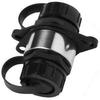
Cable coupler, marine network
Read more
|
|
|
| |
|
|
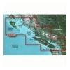
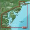
VUS038R Covers: Coverage of Raritan Bay to Virginia Beach including Tarrytown Fire Island Inlet the entire New Jersey coastline the C D Canal Delaware Bay the Delaware River to Trenton Chesapeake Bay Baltimore the Potomac River to Washington D.C. Chincote
Read more
|
|
|
| |
|
|
product : garmin bluechart g2 hxus039r us g2 (entire us) microsd & manufacturer : garmin charts manufacturer part no : 010-c1018-20.
Read more
|
|
|
| |
|
|
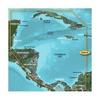
HXUS031R Covers:Detailed coverage of the northern coast of Central America from Cancun, Mexico to Barranquilla, Colombia, including the Panama Canal in its entirety. General coverage of the northern half of the Gulf of Panama. Also includes detailed...
Read more
|
|
|
| |
|
|
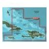
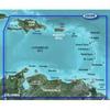
Covers the Caribbean from Haiti to Trinidad & Tobago, including Puerto Rico and all of the Lesser Antilles. Also includes the Colombian and Venezuelan coasts from Barranquilla, Colombia to the mouth of the Orinoco River, including Lake Maracaibo and the G
Read more
|
|
|


 Switch to grid view