| |

|
 |
Mapping Coverage: New Zealand North
Read more 
|
|
 |
| |

|
|
Southeast Florida
Read more
|
|
|
| |
|
|
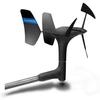
gWind™ Transducer OnlyThe gWind transducer features twin-fin technology with 3-bladed propeller for more accurate TWS in lighter air while the twin-fin design gives a more stable TWA. The 3-bladed propeller, unlike a cups design, is always efficient
Read more
|
|
|
| |

|
|
Card Includes: Detailed Mapping Software of Atchafalaya Bay to Brownsville, including Port Arthur, Galveston Bay, Matagorda Bay, and Padre Island
Read more
|
|
|
| |
|
|
Garmin VPC412S - Admiralty G. WA to Cairns - SD Card
Read more
|
|
|
| |
|
|
VAE002R Covers:General coverage of the Chinese coast from Wenzhou to Dandong, the North and South Korean coasts in their entirety, and the Russian coast east to Nakhodka. Also includes general coverage of the southern tip of Japan from Yonago around to Ko
Read more
|
|
|
| |
|
|
Covers: Eastern Nova Scotia from Halifax to Sydney, around Cape St. Lawrence, and Down to Antigonish
Read more
|
|
|
| |

|
|
Maps of Jacksonville to Bahamas
Read more
|
|
|
| |

|
|
Covers: The Coasts of Maine and New Brunswick from Machias Bay, ME to Saint John, NB
Read more
|
|
|
| |

|
|
Pre Programmed Card Includes: Mapping Coverage of Les Mechins to St. Georges Bay - For: GPSMAP 4XXX, 5X5, 5x0 and 4X0 Series
Read more
|
|
|
| |
|
|
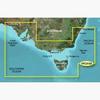
2Pc415S Covers: Detailed Coverage Of The Southeastern Coast Of Australia From Port Stephens To Fowlers Bay. Also Includes Detailed Coverage Of Sydney, Flinders And King Islands, Tasmania, Melbourne, And Adelaide.
Read more
|
|
|
| |

|
|
Humminbird HDR 610P Brand New Includes One Year Warranty, Product # 406480-1P The Humminbird HDR 610 In-Dash Digital Depth Sounder provides reliable digital depth readings, and offers customizable bezel and face colors to complement installed gauges....
Read more
|
|
|


 Switch to grid view