| |
|
 |
Maps & Add-Ons . VPC417S Covers: Includes the entire coast of the South Island, including the Bounty Islands to the southeast and Snares islands to the southwest; also includes the southernmost part of the North Island, from Foxton Beach to Cape Turnagain
Read more 
|
|
 |
| |

|
|
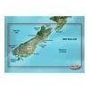
Mapping Coverage: New Zealand
Read more
|
|
|
| |

|
|
Card Includes: Detailed Mapping Software of Atchafalaya Bay to Brownsville, including Port Arthur, Galveston Bay, Matagorda Bay, and Padre Island
Read more
|
|
|
| |
|
|
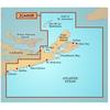
Covers: Eastern Nova Scotia from Halifax to Sydney, around Cape St. Lawrence, and Down to Antigonish
Read more
|
|
|
| |

|
|
Covers: The Coasts of Maine and New Brunswick from Machias Bay, ME to Saint John, NB
Read more
|
|
|
| |

|
|
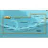
Pre Programmed Card Includes: Mapping Coverage of Les Mechins to St. Georges Bay - For: GPSMAP 4XXX, 5X5, 5x0 and 4X0 Series
Read more
|
|
|
| |
|
|
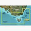
2Pc415S Covers: Detailed Coverage Of The Southeastern Coast Of Australia From Port Stephens To Fowlers Bay. Also Includes Detailed Coverage Of Sydney, Flinders And King Islands, Tasmania, Melbourne, And Adelaide.
Read more
|
|
|
| |
|
|
BlueChart g2 Vision offers the same rich detailed charting of BlueChart g2 to help you get the most out of your unit. In addition, g2 Vision features a growing database of high-resolution satellite imagery, above and below the water 3D perspective, auto g
Read more
|
|
|
| |
|
|
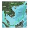
VAE004R Covers: General coverage of the coasts of the Malay Peninsula, Thailand, Cambodia, Vietnam, and China east to Quanzhou, including Hainan Island and Macau. Included in this overall general coverage are numerous detailed charts covering areas such a
Read more
|
|
|
| |
|
|
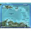
Covers the Caribbean from Haiti to Trinidad & Tobago, including Puerto Rico and all of the Lesser Antilles. Also includes the Colombian and Venezuelan coasts from Barranquilla, Colombia to the mouth of the Orinoco River, including Lake Maracaibo and the G
Read more
|
|
|
| |

|
|
Coverage of the Pacific Ocean from the Hawaiian to Mariana Islands. Includes coverage of Guam, Midway, and Johnston Atoll. General coverage of Palmyra Atoll and the Marshall Islands also included.
Read more
|
|
|
| |
|
|
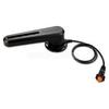
GRF™ 10 - Rudder Feedback SensorCompatible DevicesPair this sensor with the GHP 12™ to provide rudder position feedback and to detect and avoid rudder stops while sailing or boating.The GRF 10 uses a magnetic sensor to relay position information
Read more
|
|
|


 Switch to grid view