| |
|
 |
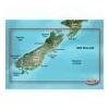
Maps & Add-Ons . VPC417S Covers: Includes the entire coast of the South Island, including the Bounty Islands to the southeast and Snares islands to the southwest; also includes the southernmost part of the North Island, from Foxton Beach to Cape Turnagain
Read more 
|
|
 |
| |
|
|
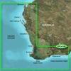
Garmin VPC410S - Esperance to Exmouth Bay - SD Card 010-C0868-00 Garmin Vpc410S Esperance To Exmouth Bay G2 Vision VPC410S Covers: Detailed coverage of the Southwest coast of Australia from Esperance to Dorre Island and Exmouth Bay. Detailed coverage of G
Read more
|
|
|
| |
|
|
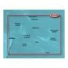
VPC019R Covers:general coverage of the coasts of Tonga, Samoa, American Samoa, French Polynesia, Kiribati, and the Cook Islands. Included in this overall general coverage are numerous detailed charts covering areas such as Nukualofa, Ton., Apia, Sam., Pag
Read more
|
|
|
| |
|
|
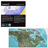
Canada LakeVü™ HD - microSD™/SD™ f/GPSMAP® Series, Montana® & Oregon® HandheldsWith maps of more than 6, 000 Canadian lakes - many with 1 foot contours throughout - this high definition-mapping product brings new levels o
Read more
|
|
|
| |
|
|
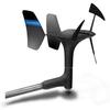
gWind™ Transducer OnlyThe gWind transducer features twin-fin technology with 3-bladed propeller for more accurate TWS in lighter air while the twin-fin design gives a more stable TWA. The 3-bladed propeller, unlike a cups design, is always efficient
Read more
|
|
|
| |
|
|
Plug a BlueChart g2 Vision SD data card into your chartplotter, and youll get a whole new perspective on nautical navigation. BlueChart g2 Vision offers the same rich detailed charting of BlueChart g2 to help you get the most out of your unit. In addition
Read more
|
|
|
| |
|
|
BlueChart g2 Vision offers the same rich detailed charting of BlueChart g2 to help you get the most out of your unit. In addition, g2 Vision features a growing database of high-resolution satellite imagery, above and below the water 3D perspective, auto g
Read more
|
|
|
| |
|
|
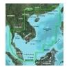
VAE004R Covers: General coverage of the coasts of the Malay Peninsula, Thailand, Cambodia, Vietnam, and China east to Quanzhou, including Hainan Island and Macau. Included in this overall general coverage are numerous detailed charts covering areas such a
Read more
|
|
|
| |
|
|
Enhance your boats marine instrumentation capabilities. This versatile thru-hull sensor provides depth and water temperature data and sends it to your NMEA 0183 Garmin digital marine instrument display or chartplotter.
Read more
|
|
|
| |
|
|
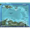
Covers the Caribbean from Haiti to Trinidad & Tobago, including Puerto Rico and all of the Lesser Antilles. Also includes the Colombian and Venezuelan coasts from Barranquilla, Colombia to the mouth of the Orinoco River, including Lake Maracaibo and the G
Read more
|
|
|
| |
|
|
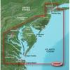
VUS038R Covers: Coverage of Raritan Bay to Virginia Beach including Tarrytown Fire Island Inlet the entire New Jersey coastline the C D Canal Delaware Bay the Delaware River to Trenton Chesapeake Bay Baltimore the Potomac River to Washington D.C. Chincote
Read more
|
|
|
| |

|
|
Coverage of the Pacific Ocean from the Hawaiian to Mariana Islands. Includes coverage of Guam, Midway, and Johnston Atoll. General coverage of Palmyra Atoll and the Marshall Islands also included.
Read more
|
|
|


 Switch to grid view