| |

|
 |
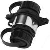
Garmin B175L Bronze 20 Degree Thru-Hull Transducer - 1kW, 8-Pin
Read more 
|
|
 |
| |
|
|
Garmin B175L Bronze 12 Degree Thru-Hull Transducer - 1kW, 8-Pin
Read more
|
|
|
| |
|
|
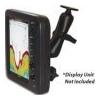
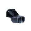
The 585-RAM-MNT is an overhead mounting solution for FCV585 and FCV620 fish finder displays. This rugged, versatile mounting system gives you the capability to mount either the FCV585 or the FCV620 from an overhead, bulkhead or just about any flat surface
Read more
|
|
|
| |
|
|
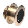
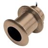
B117 Bronze Thru-Hull Depth/Temp - 8-PinGarmin's bronze, thru-hull mount transducer provides depth and temperature data. Garmin's transducer has an operating frequency of 50kHz or 200kHz and mounts on a 0-8° deadrise angle.
Read more
|
|
|
| |
|
|
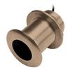
Garmin B75M Bronze 12 Degree Thru-Hull Transducer - 600W, 8-Pin
Read more
|
|
|
| |
|
|
Cable coupler, marine network
Read more
|
|
|
| |
|
|
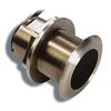
Our bronze thru-hull mount transducer performs well at high speeds and is an excellent choice for fiberglass and metal hulls. This 8-pin 500 W transducer has a depth of 900 ft; an operating frequency of 77/200 kHz; a beamwidth of 45/15 degrees; and a 8 to
Read more
|
|
|
| |
|
|
Airmar P66 200/50kHz Plastic Transom Mount Transducer (8-pin)010-10192-21Our plastic, transom mount transducer provides depth, speed and temperature data. This transducer has an operating frequency of 50 or 200 kHz and mounts on a 2-20° transom angle
Read more
|
|
|
| |
|
|
HUMMINBIRD ACCESSORIES Transom Mount Transducer (Includes 20 ft. Cable & Hardware). XNT 9 DI T Single/Down Imaging, 200kHz+455/800kHz, Temp, In-Hull Mounting Epoxy.
Read more
|
|
|
| |
|
|
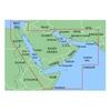
VAW005R Covers:Coverage of the Arabian Peninsula beginning at the Mediterranean Sea from Beirut to Alexandria. Coverage includes the Suez Canal, Gulf of Aqaba, and the Red Sea and Gulf of Aden in their entirety. Includes the Strait of Hormuz, Gulf of Oman
Read more
|
|
|
| |
|
|
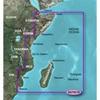
VAF001R Covers:General coverage of the east coast of Africa from the Gulf of Tadjoura to the Bay of Maputo, including Mogadishu, Som., Mombasa, Ken., and Dar es Salaam, Tan. Also inclu
Read more
|
|
|
| |
|
|
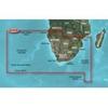
Includes detailed coverage of Durban S. Af. and Maputo, Moz. Also includes detailed coverage of the Tristan da Cunha Group, the island of St. Helena, and the Prince Edward Islands. 010-C0748-00 Garmin Vaf002R South Africa G2 Vision Sd VAF002R Covers: Deta
Read more
|
|
|


 Switch to grid view